
Balnakeil Craft Village
Half a mile west of Durness is Balnakeil Craft Village, home to a range of local artists & businesses including a chocolatier, hairdresser, art galleries, paintings & prints, ceramics, woodwork, glass work & more unique crafts. Google maps link. |

North West Highlands Geopark
At 3,000 million years old, the rocks at the seashore are even older than the hills – and what hills they are! Where else can you experience a skyline that compares to the ridges of Foinaven and Arkle, or classic hills like Suilven or Stac Pollaidh? In places like this it’s not just the eagles or the peregrines that soar. This is the most sparsely populated corner of Europe. Set yourself free in a place with space to spare. |

Lotte Glob Sculpture Croft
World-renowned ceramic artist's home, "a magical world where ceramic art works live in harmony with nature". Open in May and September and at times by appointment: visit the artist's web site for up-to-date details. |

Smoo Cave
Smoo Cave on the shore just east of Durness is a large combined sea and freshwater cave, thought to be the largest limestone sea cave. The cave name is thought to originate from the Norse 'smjugg' or 'smuga', meaning a hole or hiding-place. The outer cave is easily accessible to those with stout shoes and the stamina for a hundred steps down to the beach. A fascinating geological tour of the inner cave by boat is offered by Smoo Cave Tours. |

Faraid Head – Jutting into the North Atlantic Ocean, Faraid Head is characterised by undulating sand dunes and coastal grasses and is an excellent place to see the Scottish primrose. Ask about the Highland Council Countryside Ranger service to help you make the most of your trip.
|

Sango Bay – Above the sands of Sango Bay lie the most exposed outcrops of the Moine Thrust. A geologists paradise, this is a spectacular place to view geological features.
Google maps link. (Google calls it Durness Beach) |

Durness Golf Club The most north-westerly golf club on mainland Britain, with spectacular views over sandy beaches and the north Atlantic ocean. Not to be missed! Here is Golf Monthly's glowing review of the club. More information on the golf club web site. |

Durness Walking Network The Highland Council have created a tremendous guide to walks and sites in and around Durness. Download here. "The area covered by the Durness path network may seem largely wild and remote in character but it remains a working landscape that is also highly important for wildlife and plants. Most of the routes pass through extensively grazed areas, including open hill and heath, where dogs should be kept under close control particularly before and during the lambing season and through the breeding season for birds – most of which are ground nesting in this area. Common sense with regards to young livestock is necessary and areas with calves and lambs should be avoided. Please keep to the routes as described in the booklet and respect the areas life and work." |

Village Hall and John Lennon Memorial Garden.
Durness Village Hall provides space for sports, coffee mornings, visiting theatre and music performances, a meeting place for community groups and more. Find more information on the hall web site or on its Facebook page. |
Ceannabeinne Township Trail
Once a thriving crofting community, home to about 50 people and 10 houses, the township was destroyed in a year by the Highland Clearances. Little survives except for a few low stone walls marking the homes and gardens that stood here. A series of signboards directs you through the site and its story, bringing you to the shore (beware very steep cliffs, dangerous for children and for adults without good footwear) . Walk Highlands description of the walk and the Historical Marker Database tells the story of the community. A search on Flickr shows how popular the area is and gives some idea of the terrain. |

Balnakeil Church
Was built in 1619 and was in use until about 1814 when the present church was built, but it is said to have once been an outpost of a monastery at Applecross, founded by the Irish monk St Maelrubba (642-722).
A tomb built into the south wall of the church is the last resting - place of Donald MacMurdo, known as Dombnull MacMhurchaidh a robber supposed to have been responsible for at least eighteen murders. The legend on the stone slab above the tomb reads
Donald Mackmurchou hier lyis lo
was il to his freind var [worse] to his fo
true to his maister in veird and vo
Google maps link.
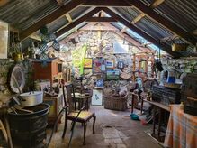
Vintage Durness
On the main road just west of the junction and the square, a new museum with collections of material from Durness and the area.
On the main road just west of the junction and the square, a new museum with collections of material from Durness and the area.

|

|
|
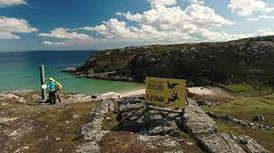
Golden Eagle Zip Line
One of the most beautiful beaches in Northern Highlands now has concrete foundations on each side with a zip-line joining them. 40 mph with some amazing views! Facebook link |

The Cape Wrath Trail
is a 200 mile hiking trail of from Fort William to the north-west corner of Scotland. It is unofficial, not way-marked, has few facilities en route and even fewer paths. The terrain is often boggy, the rain often unrelenting. But described by all who’ve done it as magnificent. The official web site and Walkhighlands description of the route are essential reading before you start! |